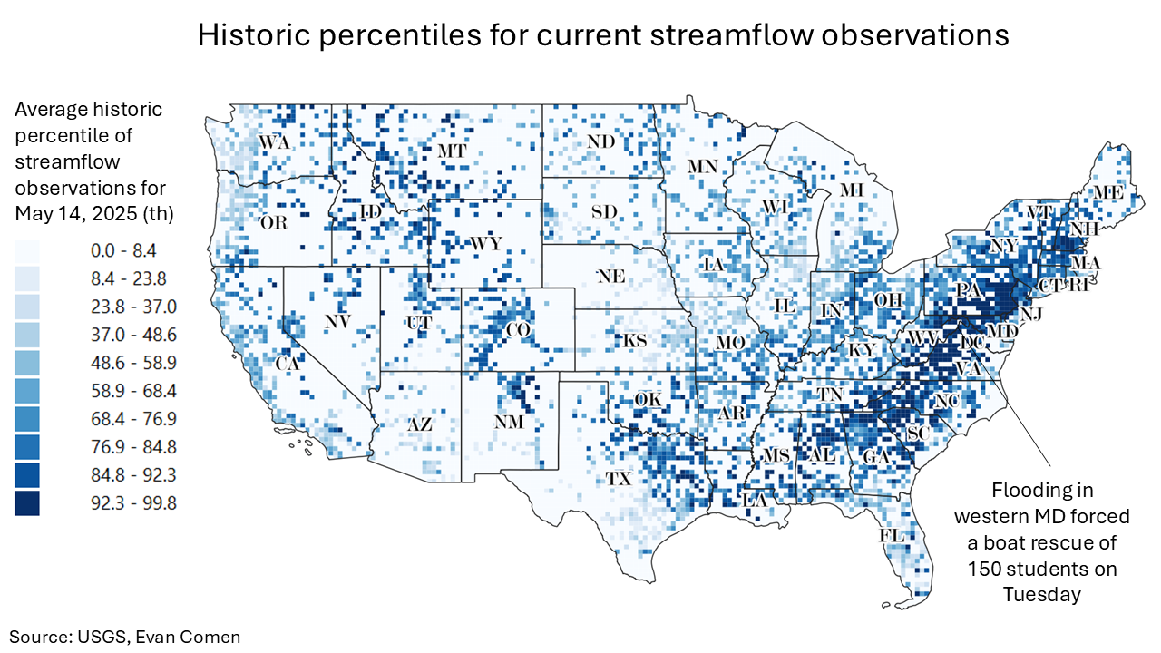
Flooding Forced a Boat Rescue of Maryland Students: Here Is Where Flooding Is at Historic Extremes
 https://climate-crisis-247-bucket.nyc3.digitaloceanspaces.com/wp-content/uploads/2025/05/07222256/Historic-percentiles-for-current-streamflow-observations-150x150.png
Severe flash flooding has struck parts of the Mid-Atlantic, with dozens of counties experiencing their worst flooding in decades. On Tuesday, rising floodwaters necessitated a boat rescue of approximately 200 students and staff from Westernport Elementary School in western Maryland.
Tesla takedown? A Timeline of Tesla Vandalism in the United States
Not in Kansas anymore? Tornado Alley Is Expanding South Into These Cities
The flooding was caused by a slow-moving storm system that brought heavy rainfall to the region. Flash flood emergencies were declared in multiple counties across Virginia and Maryland, with roads closed due to rising waters and fallen trees. In Albemarle County, Virginia, a 12-year-old boy tragically died after being swept away by floodwaters.
There are currently 345 counties under flood watches and warnings issued by the National Weather Service, representing over 36 million Americans. At some observation stations, current streamflow levels are at record highs, and water levels are multiple feet above flooding thresholds. A closer look at real-time data from the U.S. Geological Survey reveals the places where flooding is the worst right now.
To determine where flooding is at historic extremes right now, Climate Crisis 247 reviewed data on current flooding observations from the U.S. Geological Survey. Stations were ranked based on the historic percentile of current streamflow. Stations where current streamflow conditions are in the highest percentile – meaning where streamflow levels are at their most record-breaking – were ranked highest. Supplemental data on current water levels and flooding thresholds are also from the USGS. Station locations were paired to Census Bureau places using nearest neighbor analysis.
20. Youghiogheny River at Confluence, PA (Somerset County)

- Current streamflow: 18,900 cubic feet per second (99.37th percentile)
- Current water level: 10.40 feet
- Flooding threshold: 12.00 feet
19. Patterson Creek at Fort Ashby, WV (Mineral County)
- Current streamflow: 5,090 cubic feet per second (99.37th percentile)
- Current water level: 10.33 feet
- Flooding threshold: 9.00 feet
18. Potomac River at Paw Paw, WV (Morgan County)

- Current streamflow: 63,100 cubic feet per second (99.39th percentile)
- Current water level: 27.40 feet
- Flooding threshold: 25.00 feet
17. Stonycreek River at Riverside, PA (Cambria County)

- Current streamflow: 10,900 cubic feet per second (99.40th percentile)
- Current water level: 10.20 feet
- Flooding threshold: 19.00 feet
16. Abram Creek at Kitzmiller, MD (Garrett County)
- Current streamflow: 902 cubic feet per second (99.41th percentile)
- Current water level: 5.36 feet
- Flooding threshold: 10.00 feet
15. Chassahowitzka River at Homosassa, FL (Citrus County)

- Current streamflow: 920 cubic feet per second (99.41th percentile)
- Current water level: 1.04 feet
- Flooding threshold: 5.23 feet
14. Hazel River at Culpeper, VA (Culpeper County)

- Current streamflow: 15,900 cubic feet per second (99.42th percentile)
- Current water level: 20.22 feet
- Flooding threshold: 16.00 feet
13. Walker Creek at Pearisburg, VA (Giles County)

- Current streamflow: 7,660 cubic feet per second (99.44th percentile)
- Current water level: 11.02 feet
- Flooding threshold: 11.00 feet
12. Chassahowitzka River at Sugarmill Woods, FL (Citrus County)

- Current streamflow: 106 cubic feet per second (99.45th percentile)
- Current water level: 1.33 feet
- Flooding threshold: 5.05 feet
11. Aughwick Creek at Shirleysburg, PA (Huntingdon County)

- Current streamflow: 7,670 cubic feet per second (99.50th percentile)
- Current water level: 11.44 feet
- Flooding threshold: 10.00 feet
10. North Branch Potomac River at Wiley Ford, WV (Mineral County)

- Current streamflow: 28,300 cubic feet per second (99.51th percentile)
- Current water level: 20.22 feet
- Flooding threshold: 17.00 feet
9. Dunning Creek at Bedford, PA (Bedford County)

- Current streamflow: 6,650 cubic feet per second (99.52th percentile)
- Current water level: 10.93 feet
- Flooding threshold: 8.00 feet
8. Opequon Creek at Winchester, VA (Winchester city)

- Current streamflow: 2,720 cubic feet per second (99.53th percentile)
- Current water level: 10.95 feet
- Flooding threshold: 10.00 feet
7. Lick Creek at Beech Grove, IN (Marion County)

- Current streamflow: 871 cubic feet per second (99.55th percentile)
- Current water level: 4.77 feet
- Flooding threshold: 7.00 feet
6. Canoochee River at Claxton, GA (Evans County)

- Current streamflow: 8,410 cubic feet per second (99.55th percentile)
- Current water level: 14.13 feet
- Flooding threshold: 11.00 feet
5. Youghiogheny River at Ohiopyle, PA (Fayette County)
- Current streamflow: 19,300 cubic feet per second (99.64th percentile)
- Current water level: 11.91 feet
- Flooding threshold: 20.00 feet
4. Sideling Hill Creek at Little Orleans, MD (Allegany County)

- Current streamflow: 6,450 cubic feet per second (99.65th percentile)
- Current water level: 9.50 feet
- Flooding threshold: 7.50 feet
3. Robinson River at Orange, VA (Orange County)

- Current streamflow: 10,800 cubic feet per second (99.70th percentile)
- Current water level: 16.75 feet
- Flooding threshold: 11.00 feet
2. Town Creek at Oldtown, MD (Allegany County)

- Current streamflow: 8,350 cubic feet per second (99.99th percentile)
- Current water level: 13.71 feet
- Flooding threshold: 14.00 feet
1. Licking Creek at Pecktonville, MD (Washington County)

- Current streamflow: 7,410 cubic feet per second (99.99th percentile)
- Current water level: 11.18 feet
- Flooding threshold: 10.00 feet
Sponsor
Find a Vetted Financial Advisor
- Finding a fiduciary financial advisor doesn't have to be hard. SmartAsset's free tool matches you with up to 3 financial advisors that serve your area in 5 minutes.
- Each advisor has been vetted by SmartAsset and is held to a fiduciary standard to act in your best interests. Get on the path toward achieving your financial goals!