Rare Winter Storm Could Bring ‘Thundersnow’ To These Cities
A potent early-season winter storm is poised to sweep across the Great Lakes over the next 72 hours, delivering a unique mix of heavy snow, rapid intensification, and the potential for a rare phenomenon meteorologists are calling thundersnow. Thundersnow occurs when strong upward motion inside a winter storm becomes intense enough to generate lightning and thunder, usually within narrow bands of extremely heavy snowfall.
Forecast guidance from the National Weather Service shows a tightly wound low-pressure system tracking across the Upper Midwest, tapping an unusually deep plume of moisture while dragging Arctic air southward behind it. The clash of ingredients has meteorologists highlighting not just high snowfall rates, but convective bursts capable of producing lightning embedded within lake-enhanced snow bands.
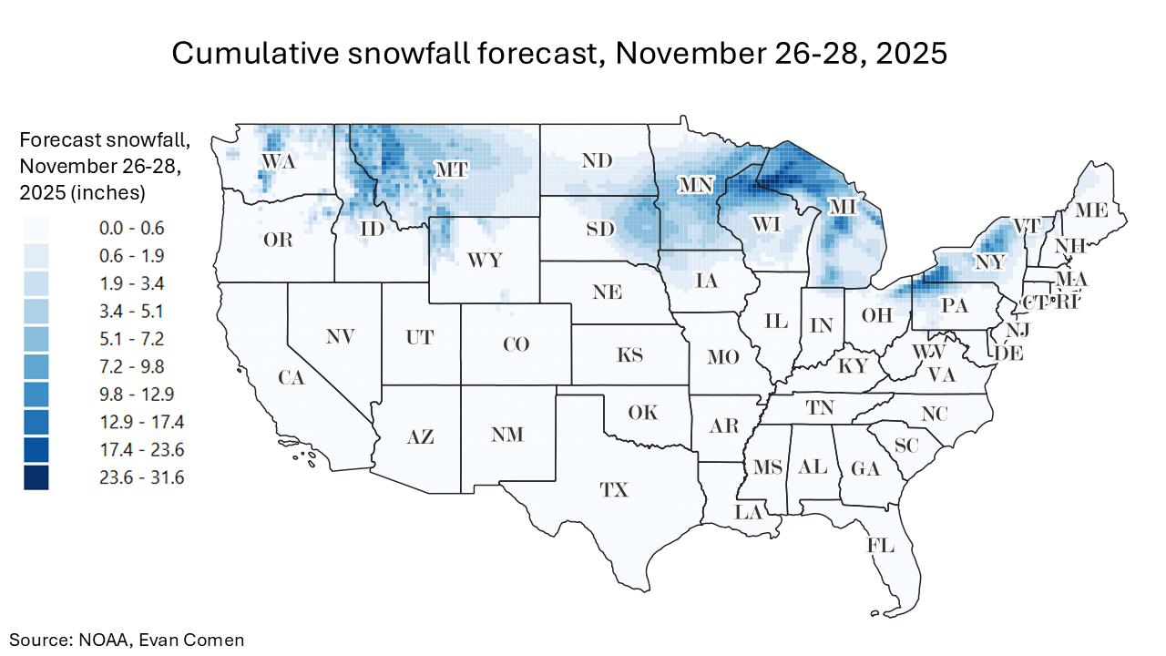
Temperatures across northern Ohio, Michigan, Wisconsin, and Minnesota are expected to remain cold enough for nearly all precipitation to fall as snow, with many communities staying locked in the 20s and low 30s through the duration of the event. As the storm intensifies over the relatively warm Great Lakes, narrow but powerful lake-effect and lake-enhanced bands could deliver brief whiteout conditions and some of the highest late-November accumulations in years. A closer look at the data reveals the cities that could experience thundersnow in the next few days.
To determine the cities that could experience thundersnow this week, Climate Crisis 247 reviewed forecast data from the NOAA’s National Digital Forecast Database. Cities in the Great Lakes region were ranked based on total forecast cumulative snowfall for November 26 to 28, 2025. Only cities with at least 25,000 residents were considered.
10. Portage, MI
Portage is expecting nearly 7 inches of snow as lake-enhanced bands sweep across Southwest Lower Michigan. Cold air locked in the upper 20s will ensure that precipitation remains all snow throughout the event. Brief whiteout bursts are possible as the stronger bands pivot inland from Lake Michigan.
9. Mentor, OH
Mentor sits directly downwind of Lake Erie, placing it in prime position for heavy, lake-enhanced snowfall as the storm intensifies. Forecasts show more than 7 inches falling through November 28, with temperatures cold enough to sustain high snowfall rates. Thundersnow is possible here if convective bands develop over the lake and move ashore.
8. Shaker Heights, OH
Shaker Heights is set to receive over 7.7 inches of snow, driven largely by strong northerly flow funneling moisture off Lake Erie. The city lies within the Erie Drift Plain, an area highly susceptible to quick-forming lake-effect bands. Residents may see rapid changes in visibility as narrow convective bands push inland.
7. Kalamazoo, MI
Kalamazoo is poised for 7.7 inches of accumulation as snow bands extend well inland from Lake Michigan. Cold, stagnant air will enhance snowfall efficiency across Southwest Lower Michigan. The city could see the heaviest bursts during the system’s peak intensification Wednesday into Thursday morning.
6. Cleveland Heights, OH
Cleveland Heights is forecast to pick up nearly 8 inches of snow as the storm taps into deep moisture from Lake Erie. Its elevated terrain often amplifies lake-effect snow, a pattern likely to repeat with this system. Brief, intense convective bursts may accompany the strongest bands.
5. Euclid, OH
Euclid is expecting roughly 8 inches of accumulation, fueled by a persistent fetch of moisture across Lake Erie. The city’s lakeshore location makes it one of the first to experience the heaviest banding as winds shift.

4. Duluth, MN
Duluth is in line for nearly 9 inches of snowfall as Arctic air pours over the relatively warm waters of Lake Superior. The city’s elevation and proximity to the lake often magnify snowfall totals during early-season storms. Heavy snow and brief whiteout potential will be highest Wednesday night into Thursday.
3. Superior, WI
Superior is forecast to receive more than 9.2 inches thanks to strong northeasterly flow blowing across Lake Superior. The city sits at the western tip of the lake, a region where banding frequently converges and intensifies. Travel could be difficult at times as the heaviest lake-enhanced snow moves ashore.
2. Erie, PA
Erie is one of the top locations for this storm, with projections showing over 10 inches of snow from November 26–28. The city’s direct exposure to Lake Erie makes it a hotspot for intense lake-effect and lake-enhanced snowfall. Thundersnow is a possibility if deep convection organizes over the lake.
1. Jamestown, NY
Jamestown tops the list with a forecast of nearly 13 inches of snow forecast as strong lake-effect bands barrel inland from Lake Erie. Located in the snow-prone higher terrain of southwestern New York, the city often sees the heaviest totals during events like this. Conditions could deteriorate quickly if convective bands develop, bringing the best chance of thundersnow in the region.