As Southeast Heat Wave Peaks on Tuesday, These Cities Will Be Hit The Hardest
 https://climate-crisis-247-bucket.nyc3.cdn.digitaloceanspaces.com/wp-content/uploads/2025/07/07211326/NWS-Heat-Risk-Forecast-July-29-2025-150x150.png
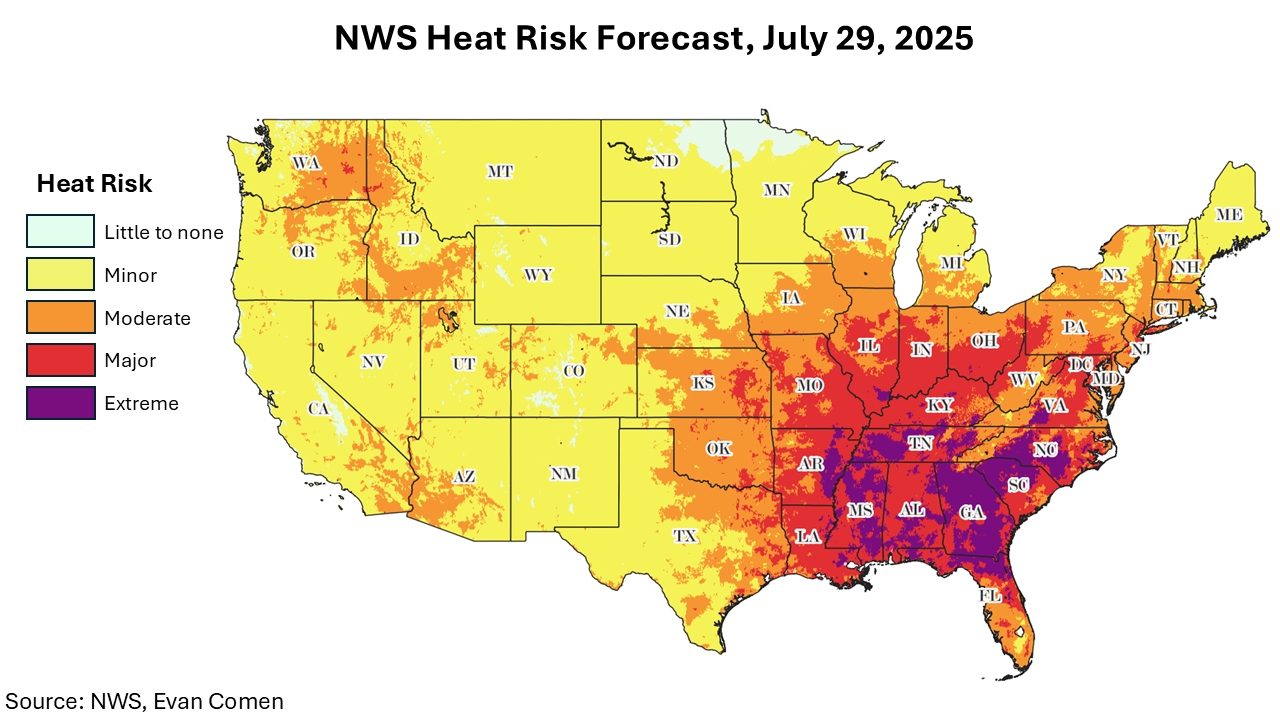
As a heat wave condenses in the Southeast, more than two dozen cities from Florida to Connecticut are forecast to break heat records. Temperatures in Atlanta are forecast to hit 99.9°F on Wednesday, breaking a heat record from 1980 by 1.8°F, while smaller cities like Mobile and Tallahassee could also see dramatic anomalies.
While temperatures will breach 100°F in hundreds of counties, dry-bulb temperatures are just one component of heat risk. In an effort to model comprehensive heat risk, the National Weather Service publishes a daily HeatRisk forecast, a composite metric measuring temperatures, humidity, duration of heat, and how unusual heat is for the time of year in a given geography.
Whence the next pandemic? Cities Where the Next Pandemic Is Most Likely to Break Out
Hot property? From Maui to Malibu, These Affluent Enclaves Are Becoming Wildfire Hotspots
NWS forecasts show that nationwide heat risk will peak on Tuesday. While 3.4 million Americans will be exposed to extreme heat risk – the most dangerous category of heat risk – on Monday, that number will rise to 8.8 million on Tuesday, spread across 80 counties. A closer look at the data reveals the cities with the greatest heat risk this week.
To determine the cities with the highest heat risk this week, Climate Crisis 247 reviewed data on heat risk from the NOAA’s National Weather Service. Cities were ranked based on average NWS HeatRisk score for the period July 28 to 30, 2025. Supplemental data on forecast temperature maximums are from the NOAA’s National Digital Forecast Database. Only cities with at least 125,000 residents were considered. Population data is from the U.S. Census Bureau.
25. Savannah, GA

- NWS HeatRisk score, July 28, 2025: 3.75/4 (high of 100.1°F)
- NWS HeatRisk score, July 29, 2025: 3.24/4 (high of 99.2°F)
- NWS HeatRisk score, July 30, 2025: 2.97/4 (high of 96.5°F)
- Total population: 147,583
24. Jacksonville, FL

- NWS HeatRisk score, July 28, 2025: 3.58/4 (high of 98.0°F)
- NWS HeatRisk score, July 29, 2025: 3.44/4 (high of 98.4°F)
- NWS HeatRisk score, July 30, 2025: 2.95/4 (high of 95.2°F)
- Total population: 950,203
23. Montgomery, AL

- NWS HeatRisk score, July 28, 2025: 3.00/4 (high of 96.6°F)
- NWS HeatRisk score, July 29, 2025: 3.52/4 (high of 98.8°F)
- NWS HeatRisk score, July 30, 2025: 3.52/4 (high of 99.9°F)
- Total population: 199,819
22. Mobile, AL

- NWS HeatRisk score, July 28, 2025: 3.09/4 (high of 94.4°F)
- NWS HeatRisk score, July 29, 2025: 3.49/4 (high of 98.1°F)
- NWS HeatRisk score, July 30, 2025: 3.47/4 (high of 98.2°F)
- Total population: 186,316
21. Huntsville, AL

- NWS HeatRisk score, July 28, 2025: 3.00/4 (high of 94.1°F)
- NWS HeatRisk score, July 29, 2025: 3.50/4 (high of 96.3°F)
- NWS HeatRisk score, July 30, 2025: 3.58/4 (high of 97.7°F)
- Total population: 215,025
20. Gainesville, FL

- NWS HeatRisk score, July 28, 2025: 3.94/4 (high of 97.8°F)
- NWS HeatRisk score, July 29, 2025: 3.21/4 (high of 99.0°F)
- NWS HeatRisk score, July 30, 2025: 3.00/4 (high of 95.0°F)
- Total population: 142,414
19. Chattanooga, TN

- NWS HeatRisk score, July 28, 2025: 3.00/4 (high of 94.3°F)
- NWS HeatRisk score, July 29, 2025: 3.76/4 (high of 96.3°F)
- NWS HeatRisk score, July 30, 2025: 3.90/4 (high of 96.8°F)
- Total population: 181,288
18. Greensboro, NC

- NWS HeatRisk score, July 28, 2025: 3.77/4 (high of 95.5°F)
- NWS HeatRisk score, July 29, 2025: 3.50/4 (high of 94.9°F)
- NWS HeatRisk score, July 30, 2025: 3.52/4 (high of 95.2°F)
- Total population: 297,202
17. Columbia, SC

- NWS HeatRisk score, July 28, 2025: 3.85/4 (high of 101.3°F)
- NWS HeatRisk score, July 29, 2025: 3.54/4 (high of 100.7°F)
- NWS HeatRisk score, July 30, 2025: 3.52/4 (high of 99.4°F)
- Total population: 136,754
16. Memphis, TN

- NWS HeatRisk score, July 28, 2025: 3.00/4 (high of 96.2°F)
- NWS HeatRisk score, July 29, 2025: 3.96/4 (high of 99.4°F)
- NWS HeatRisk score, July 30, 2025: 3.96/4 (high of 99.9°F)
- Total population: 630,027
15. Tallahassee, FL

- NWS HeatRisk score, July 28, 2025: 3.96/4 (high of 98.0°F)
- NWS HeatRisk score, July 29, 2025: 3.96/4 (high of 100.1°F)
- NWS HeatRisk score, July 30, 2025: 3.00/4 (high of 98.4°F)
- Total population: 198,259
14. Murfreesboro, TN

- NWS HeatRisk score, July 28, 2025: 3.00/4 (high of 95.8°F)
- NWS HeatRisk score, July 29, 2025: 3.97/4 (high of 97.5°F)
- NWS HeatRisk score, July 30, 2025: 3.97/4 (high of 98.3°F)
- Total population: 153,487
13. Augusta, GA

- NWS HeatRisk score, July 28, 2025: 3.74/4 (high of 101.1°F)
- NWS HeatRisk score, July 29, 2025: 3.74/4 (high of 100.4°F)
- NWS HeatRisk score, July 30, 2025: 3.64/4 (high of 99.5°F)
- Total population: 201,615
12. Knoxville, TN

- NWS HeatRisk score, July 28, 2025: 3.25/4 (high of 94.0°F)
- NWS HeatRisk score, July 29, 2025: 3.95/4 (high of 96.0°F)
- NWS HeatRisk score, July 30, 2025: 3.95/4 (high of 95.9°F)
- Total population: 191,857
11. Columbus, GA

- NWS HeatRisk score, July 28, 2025: 3.16/4 (high of 97.6°F)
- NWS HeatRisk score, July 29, 2025: 4.00/4 (high of 100.0°F)
- NWS HeatRisk score, July 30, 2025: 4.00/4 (high of 100.1°F)
- Total population: 204,572
10. Nashville, TN

- NWS HeatRisk score, July 28, 2025: 3.44/4 (high of 96.3°F)
- NWS HeatRisk score, July 29, 2025: 3.97/4 (high of 97.8°F)
- NWS HeatRisk score, July 30, 2025: 3.97/4 (high of 99.0°F)
- Total population: 684,103
9. Macon, GA

- NWS HeatRisk score, July 28, 2025: 3.59/4 (high of 98.4°F)
- NWS HeatRisk score, July 29, 2025: 3.99/4 (high of 100.4°F)
- NWS HeatRisk score, July 30, 2025: 3.99/4 (high of 99.5°F)
- Total population: 156,554
8. Raleigh, NC

- NWS HeatRisk score, July 28, 2025: 3.93/4 (high of 98.2°F)
- NWS HeatRisk score, July 29, 2025: 3.93/4 (high of 98.0°F)
- NWS HeatRisk score, July 30, 2025: 3.93/4 (high of 98.1°F)
- Total population: 465,517
7. Atlanta, GA

- NWS HeatRisk score, July 28, 2025: 3.83/4 (high of 96.3°F)
- NWS HeatRisk score, July 29, 2025: 4.00/4 (high of 99.6°F)
- NWS HeatRisk score, July 30, 2025: 4.00/4 (high of 99.9°F)
- Total population: 494,838
6. Cary, NC

- NWS HeatRisk score, July 28, 2025: 3.97/4 (high of 98.2°F)
- NWS HeatRisk score, July 29, 2025: 3.97/4 (high of 98.0°F)
- NWS HeatRisk score, July 30, 2025: 3.97/4 (high of 98.0°F)
- Total population: 174,880
5. Winston-Salem, NC

- NWS HeatRisk score, July 28, 2025: 4.00/4 (high of 96.6°F)
- NWS HeatRisk score, July 29, 2025: 3.98/4 (high of 97.3°F)
- NWS HeatRisk score, July 30, 2025: 3.98/4 (high of 97.3°F)
- Total population: 249,571
4. Durham, NC

- NWS HeatRisk score, July 28, 2025: 3.99/4 (high of 97.8°F)
- NWS HeatRisk score, July 29, 2025: 3.99/4 (high of 97.6°F)
- NWS HeatRisk score, July 30, 2025: 3.99/4 (high of 97.7°F)
- Total population: 284,094
3. Athens, GA

- NWS HeatRisk score, July 28, 2025: 4.00/4 (high of 98.6°F)
- NWS HeatRisk score, July 29, 2025: 4.00/4 (high of 101.2°F)
- NWS HeatRisk score, July 30, 2025: 4.00/4 (high of 100.5°F)
- Total population: 126,672
2. Charlotte, NC

- NWS HeatRisk score, July 28, 2025: 4.00/4 (high of 99.7°F)
- NWS HeatRisk score, July 29, 2025: 4.00/4 (high of 99.8°F)
- NWS HeatRisk score, July 30, 2025: 4.00/4 (high of 99.8°F)
- Total population: 875,045
1. Fayetteville, NC

- NWS HeatRisk score, July 28, 2025: 4.00/4 (high of 101.2°F)
- NWS HeatRisk score, July 29, 2025: 4.00/4 (high of 100.6°F)
- NWS HeatRisk score, July 30, 2025: 4.00/4 (high of 100.0°F)
- Total population: 208,697